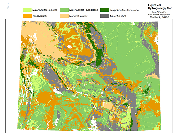
Alluvial Aquifers
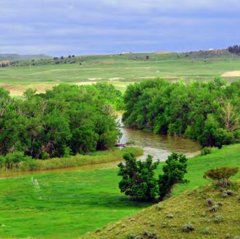
 The state’s alluvial aquifers interact closely with associated surface water flows. In high
mountain catchments, groundwater contributes to streamflow when it is discharged from springs
and seeps along “gaining” stream reaches.
Further downstream, the flow of water may be reversed
and the stream may recharge an associated alluvial aquifer in a “losing” reach. In many cases,
gaining and losing reaches alternate along the same streambed depending on the relative elevations
of groundwater and streamflow and local geologic conditions.
Bedrock Aquifers
Bedrock aquifers receive recharge at their outcrops on the basin margins from direct precipitation
and infiltrating streamflows. The state’s shallow bedrock aquifers produce freshwater close to
their recharge areas. Frequently, the same aquifer produces oil and gas from petroleum reservoirs
deeper in the basins where the groundwater is more saline and unsuitable for drinking and
agriculture. Wells that draw from the shallow margin bedrock aquifers can be artesian, flowing
artesian, or water table wells.
Additional Information
Water Resources Data System
Online water and climate data for Wyoming, and links to drought and snowpack data. Sponsored by the Wyoming Water Development Commission.
Wyoming Water Development Commission
Agency information, Wyoming Water Planning Program, research projects and funding, publications, water development projects, and public comment.
Wyoming State Engineer's Office
Groundwater regulations, forms, water well construction requirements, monitoring network information, surface water information and data, and water rights data.
U.S. Geological Survey
Data, programs and publications on groundwater, aquifers and wells; Information on quality of water resources, and USGS water science glossary and hydrologic definitions.
National Ground Water Association
Website for groundwater professionals, professional services and resources, research and journal publications, advocacy, and educational and public service information.
Wyoming Surface Water
 The use of Wyoming’s water is managed by the Wyoming State Engineer’s Office. The Wyoming
Department of Environmental Quality monitors water quality. These agencies serve important roles
in the management of Wyoming’s water resources. Any events—changes in climate, drought, vegetation
change, fires, insect outbreaks—that impact our mountain watersheds will have major consequences
for all Wyoming water users and water users downstream.
Wyoming is the fifth driest state in the United States. More than 70 percent of the state receives
less than 16 inches of precipitation on average each year. At 6,700 feet, Wyoming also has the
second highest mean elevation in the United States. Mountain snowpack runs off to form the
headwaters of Wyoming’s major river systems and helps recharge aquifer systems.
Three of America's major river systems have their headwaters in Wyoming: the Missouri, Colorado, and Columbia. Other major rivers include the Yellowstone, Bighorn, North Platte, Green, and Snake.
Surface Water Map of Wyoming
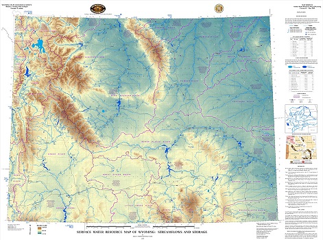
The Wyoming State Geological Survey in 2009 released
Surface Water Resource Map of Wyoming: Streamflows and Storage,
showing streamflows and surface water storage in Wyoming. This unique
and comprehensive map product includes current and historic streamflow and reservoir capacity data.
The map
is available as a free download or for purchase in hardcopy with accompanying CD that illustrates the minimum, average, and maximum streamflow rates at 330 U.S. Geological Survey
gage locations across Wyoming and the maximum storage capacities of reservoirs and volumes of major lakes. The map also features watershed boundaries, surface water
facts and trivia, tables of the 10 largest lakes and rivers, and inset maps of structural geology and the headwaters and routes of Wyoming rivers.
Additional Information
Wyoming State Engineer’s Office
Wyoming Department of Environmental Quality
USGS live stream gages data
Wyoming Water Resource Database
Bureau of Reclamation reservoir data
NRCS snowpack reports
Wyoming Groundwater Atlas
 Interactive Wyoming Groundwater Atlas
View the Interactive Wyoming Groundwater Atlas with ArcGIS Online.
WSGS Groundwater Publications
Publications about Wyoming's groundwater can be downloaded from the WSGS Product Catalog. 
Groundwater Salinity in the Wind River and Bighorn Basins, Wyoming
A report on the salinity of groundwater in the Wind River and Bighorn basins.
Groundwater Level Recovery in the Sandstones of the Lower Tertiary Aquifer System of the Powder River Basin, Wyoming
This report updates and supersedes the Wyoming State Geological Survey (WSGS) Report of Investigations 74 (Taboga and others, 2017).
Groundwater Salinity in the Greater Green River Basin, Wyoming
A report on the salinity of groundwater in the Greater Green River Basin.
Groundwater Salinity in Wyoming
A report on the salinity of groundwater in Wyoming.
Groundwater Salinity in the Powder River Basin, Wyoming
A report on the salinity of groundwater in the Powder River Basin.
Characterization of Evaporite Karst Features in the Southern Laramie Basin, Wyoming
A report on the occurrence of sinkholes and other evaporite-related karst features in the southern Laramie Basin, including in and around the city of Laramie.
Groundwater Response in the Sandstones of the Wasatch and Fort Union Formations, Powder River Basin, Wyoming
This publication includes a discussion on the geologic setting of the Powder River Basin as well as coalbed hydraulic properties and recharge. The study also includes results from individual water monitoring well sites with full-color figures and maps
Groundwater Salinity in the Denver-Julesburg Basin, Wyoming
A report on groundwater salinity in the Denver-Julesburg Basin of southeastern Wyoming. This report examines the salinity of groundwaters that occur at depths of 5,000 ft or less in the Denver-Julesburg structural basin where significant oil and gas activity has taken place in recent years.
Wyoming State Geological Survey Statewide Groundwater Baseflow Study
A statewide groundwater study using a new model to estimate baseflow, a significant component of groundwater recharge.
Groundwater Response in the Upper Wyodak Coal Zone, Powder River Basin
A report on groundwater level responses to coalbed natural gas (CBNG) production in the Upper Wyodak coal zone. Data for this study covers the last four decades and was obtained from the BLM monitoring well network program for the Powder River Basin.
Presentations
Hydrogeology of Wyoming
A PowerPoint presentation given by Karl Taboga on July 21, 2021.
Additonal WSGS Water Publications
Available in the Water Section of the WSGS Product Catalog.