Bighorn Basin Geology
Cross
Sections
Geologic Map
Type Log
The Bighorn Basin is an elongate, northwest-trending structural basin in
north-central Wyoming. It is approximately 193 km (120 mi) long and up to 145 km (90
mi) wide. Along the axis of the basin,
the total thickness of Paleozoic, Mesozoic, and Cenozoic rocks exceeds 7,620 m
(25,000 ft). The basin is bounded on the north and east
by the Pryor and Bighorn mountains, and on the south and west by the Owl Creek,
Absaroka, and Beartooth mountains.
The present structural configuration of the Bighorn Basin resulted from the Late
Cretaceous through Early Eocene Laramide orogeny (Blackstone, 1963), during which
the peripheral mountain uplifts experienced their major
growth. The folding and faulting that formed oil-producing anticlines in the Bighorn
Basin occurred during pulses of compressional stress, mainly oriented
northeast-southwest.
The source of the oil and gas found in the basin’s Paleozoic reservoirs is the dark,
phosphatic fine-grained, marine facies of the Phosphoria Formation (Stone, 1967).
Primary hydrocarbon migration began immediately after deposition of
Triassic sediments and was completed by Early Jurassic time.
Both structural and stratigraphic traps occur in Paleozoic and Cretaceous
source-rock/reservoir systems in the Bighorn Basin. Structural plays include basin
margin subthrusts, basin margin anticlines, deep basin structures, and
sub-Absaroka-volcanics (Fox and Dolton, 1996). Later Laramide folding may have been
superimposed on or near the primary structural traps. Although most of the basin’s
production comes from anticlinal or other structural traps,
Lawson and Smith (1966) suggest that many of the structurally-controlled traps are
influenced by stratigraphic effects, including intraformational variations in
permeability and, as in the Bonzanza and Nowood fields, incised
channels in the Tensleep surface that were filled with impervious Goose Egg
sediments.
![Rattlesnake Mountain on the western flank of the Bighorn Basin. [Credit: WSGS] Rattlesnake Mountain](../images/energy/bighornbasin-rattlesnake.jpg)
Pure stratigraphic traps are also productive within the Bighorn Basin, including
Phosphoria Formation pinchouts (up-dip facies change), Tensleep Sandstone
paleogeography (dune fields versus interdune regions), and irregular truncation of
thick Tensleep Sandstone beds prior to deposition of the Phosphoria/Goose Egg
Formation (Stone, 1967; Fox and Dolton, 1996). The largest of these is the
Cottonwood Creek field in the southeast corner of the basin, a trap resulting
from an eastward, updip facies change from Phosphoria carbonate to the impermeable
red shale and anhydrite facies of the Goose Egg Formation. Oil and gas in some of
these stratigraphic traps were later released by fracturing and
faulting associated with Laramide folding. During the Laramide orogeny, these
hydrocarbons moved into older Paleozoic reservoir rocks and older structures where
they were trapped in pools. The occurrence of a common oil-water contact is
attributed to fractures joining the reservoirs.
The oil-water contact is also often tilted as a result of hydrodynamic flow (Stone,
1967).
Mesozoic formations produce a much lower percentage of the Bighorn Basin’s oil and
gas, with most production coming from the Upper Cretaceous Frontier Formation.
Source rocks in the Mesozoic include the Cody,
Frontier, Mowry, and Thermopolis black shale units (Stone, 1967).
Production
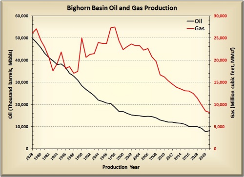
![Flatirons of the Mowry Shale on the flanks of Sheep Mountain anticline. [Credit: WSGS] Flatirons](../images/energy/bighornbasin-flatirons.jpg) The Bighorn Basin is primarily an oil-producing basin (WSGS oil and gas map). Oil was first
discovered in the basin in 1904 as a spring on the Bonanza anticline. Oil has since
been produced from more than 125 fields in the basin and from more than 30
reservoirs and/or co-mingled reservoirs ranging in age from Cambrian to Paleocene.
Seven of these fields are in the top 10 cumulative oil-producing fields in Wyoming
(WOGCC, 2023).
The Bighorn Basin is primarily an oil-producing basin (WSGS oil and gas map). Oil was first
discovered in the basin in 1904 as a spring on the Bonanza anticline. Oil has since
been produced from more than 125 fields in the basin and from more than 30
reservoirs and/or co-mingled reservoirs ranging in age from Cambrian to Paleocene.
Seven of these fields are in the top 10 cumulative oil-producing fields in Wyoming
(WOGCC, 2023).
Future Development
Despite the decreasing production levels, most fields in the Bighorn Basin still
contain a significant quantity of recoverable oil. In response, operators are
utilizing secondary and tertiary recovery techniques to revitalize old fields and to
activate fields that were not economically feasible in years past.
Future oil production in the Bighorn Basin will rely on the success of these
recovery techniques.
Unconventional reservoir plays could also improve oil and gas production in the
Bighorn Basin. Fox and Dolton’s (1996) resource assessment identified basin
center/deep gas and coalbed natural gas as significant potential future plays within
the basin. Many of the same Cretaceous formations currently being
exploited as unconventional reservoirs in other Wyoming basins also exist in the
Bighorn Basin. Future exploration for similar unconventional plays, horizontal
drilling, and hydraulic fracturing could again make the Bighorn Basin a major player
in state oil and gas production.
- ►References
-
Blackstone, D.L., Jr., 1963, Development of geologic structures in central
Rocky Mountains, in Childs, O.E., and Beebe, B.W., eds., Backbone of
the Americas—Tectonic history from pole to pole: Tulsa, Okla., American
Association of Petroleum Geologists Memoir, p. 160–179.
Fox, J.E., and Dolton, G.L., 1996, Petroleum geology of the Bighorn Basin,
north-central Wyoming and south-central Montana, in Bowen, C.E., Kirkwood,
S.C., and Miller, T.S., eds., Resources of the Bighorn Basin: Casper, Wyo. ,
Wyoming Geological Association, 47th annual field conference, Guidebook, p.
19–39.
Lawson, D.E., and Smith, J.R., 1966, Pennsylvanian and Permian influence on
Tensleep oil accumulation, Bighorn Basin, Wyoming: American Association of
Petroleum Geologists Bulletin, v. 50, no. 10, p. 2,197–2,220.
Stone, D.S., 1967, Theory of Paleozoic oil and gas accumulation in Bighorn
Basin, Wyoming: American Association of Petroleum Geologists Bulletin, v.
51, no. 10, p. 2,056–2,114.
WOGCC, 2023, Wyoming Oil and Gas Conservation Commission website, accessed
April 2023, at http://pipeline.wyo.gov/legacywogcce.cfm.
Denver Basin Geology
Cross Section (from the Colorado Geological Survey)
Geologic Map
Type
Log
The Denver Basin is an asymmetrical Laramide-age basin that covers more than 180,000
square km (70,000 square mi) in parts of Colorado, Wyoming, South Dakota, Kansas,
and Nebraska.
The bulk of the basin is in Colorado. The basin is often termed the Denver-Julesburg
Basin or the Denver-Julesburg-Wattenburg Basin. The Wyoming portion of the Denver
Basin is
in the southeastern corner of the state, and is bounded on the west by the Laramie
Range and on the north by the Hartville Uplift.
The Denver Basin has typical foreland basin-style geometry with a north-
south-trending basin axis. The strata on the western side of the basin dip steeply
toward the east, while the strata
in the eastern Denver Basin gently slope to the west. The basin is more than 3,962 m
(13,000 ft) deep, as defined by the 1.6-billion-year-old Precambrian basement. The
bulk of the strata preserved
in the Denver Basin were deposited during the Cretaceous in the Sevier foreland
basin, and later separated from similar strata in other Wyoming basins by the
Laramide orogeny. Surface outcrops in the
Denver Basin are generally Tertiary in age.
The Silo field, discovered in 1981 (Sonnenberg, 2011), is the most productive oil and
(associated) natural gas field in the basin.
Production in the Silo field is primarily from the self-sourced Cretaceous Niobrara
Formation, which is predominantly fractured chalk (reservoir) encased in tight
shales and mudstones (seal). This unconventional reservoir is conducive to
horizontal drilling and hydraulic fracturing, which significantly enhance
production.
In addition to the Niobrara Formation, other possible source rocks in the Denver
Basin include the Cretaceous Belle Fourche (Graneros), Mowry, and Carlile shales, as
well as the Greenhorn
Formation. Oil generation in these formations began during the Laramide orogeny and
continued through the Miocene (Higley and Cox, 2007).
![Tertiary White River and Arikee formations on the Goshen Hole rim. [Credit: WSGS] White River Formation](../images/energy/denverbasin-whiteriver.jpg)
Production
Oil and gas was first discovered in the Denver Basin in 1901, and it now includes
approximately 1,500 hydrocarbon fields spanning several states (Higley and Cox,
2007). The Wyoming portion of the Denver Basin has 31 named oil and gas fields, 12
of which are currently producing oil or gas (WSGS oil and gas map).
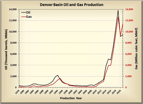
Production from these 12 fields and numerous wildcat wells steadily increased by
more than an order of magnitude since 2009, thanks in part to some of Wyoming’s most
productive oil wells. Denver Basin wells each consistently average more than 1,200
barrels of oil per month (WOGCC, 2023). Since 2017, the Denver Basin has also
accounted for at least 10% of the state’s total oil production (WOGCC, 2023).
Future Development
Although production efforts in the Denver Basin have historically focused on the
Niobrara Formation, operators are beginning to explore other unconventional plays in
the basin. Horizontal drilling
and hydraulic fracturing have increased recent production from the tight sand
formations of the Upper Cretaceous Muddy "J" Sandstone and the Codell Sandstone
Member of the Carlile Shale. As drilling techniques
and reservoir characterization in the Denver Basin are refined and improved, there
is the potential for increased production from unconventional reservoirs.
- ►References
-
Higley, D.K., and Cox, D.O., 2007, Oil and gas exploration and development
along the Front Range in the Denver Basin of Colorado, Nebraska, and
Wyoming, in Higley, DK., comp., Petroleum systems and assessment of
undiscovered oil and gas in the Denver Basin Province, Colorado, Kansas,
Nebraska, South Dakota, and Wyoming—USGS Province 39: U.S. Geological Survey
Digital Data Series DDS-69-P, chap. 2, 41 p.
Sonnenberg, S.A., 2011, Silo field summary, in Estes-Jackson, J.E.,
and Anderson, D.S., eds., Revisiting and revitalizing the Niobrara in the
central Rockies: Denver, Colo., Rocky Mountain Association of Geologists, p.
494–497.
WOGCC, 2023, Wyoming Oil and Gas Conservation Commission website, accessed
April 2023, at http://pipeline.wyo.gov/legacywogcce.cfm.
Greater Green River Basin Geology
Cross
Sections
Geologic Map
Type Log—Moxa Arch
Type Log—Rock Springs Uplift
The Greater Green River Basin encompasses the southwest portion of Wyoming and
extends south into northeastern Utah and northwestern Colorado. The footprint of the
basin covers 54,269 square km
(20,953 square mi) in Wyoming. The Greater Green River Basin is bounded on the west
by the Sevier overthrust belt, on the north by the Wind River Range, to the east by
the Rawlins Uplift and
Sierra Madre Mountain Range, and to the south by the Uinta Mountains.
The Greater Green River Basin is an amalgamation of several sub-basins, including the
Green River, Great Divide, Washakie, and Sand Wash basins. These sub-basins were
formed during the Late
Cretaceous to Early Eocene Laramide orogeny with the uplift of the Moxa arch, Rock
Springs Uplift, Cherokee Ridge arch, and Wamsutter arch. An intermittent record of
sedimentation from the Cambrian through
present is preserved in the basin, with total compacted sediment fill that can be
greater than 9,144 m (30,000 ft) thick.
Many oil and gas fields in the Greater Green River Basin occur in anticlinal traps,
which are secondary folds on the larger-scale Laramide uplifts. The giant Jonah gas
field is another type of structural trap where natural gas is trapped
in the Lance Formation sandstones within a fault-bounded wedge (Cluff and Cluff,
2004). With the exception of the Cretaceous formations, stratigraphic traps are rare
in the basin. An example of a Cretaceous stratigraphic trap is found in
Patrick Draw field, where an up-dip pinch-out of the Almond Formation traps a
significant accumulation of oil (Weimer, 1965; Weimer, 1966).
![Weber Sandstone showing dune-scale cross stratification, Irish Canyon, CO. [Credit: WSGS] Weber Sandstone](../images/energy/weber-greenriverbasin.jpg)
Primary oil production is from the Upper Cretaceous Frontier Formation and Mesaverde
Group, followed by the Lower Cretaceous Cloverly Formation. (The Cloverly Formation
is often called the "Dakota Sandstone"
by the hydrocarbon industry, which is an informal name borrowed from neighboring
states. Its official name in Wyoming is the Cloverly Formation.) Carbon dioxide and
helium production on the LaBarge platform
is from the Mississippian Madison Limestone.
Hydrocarbons are also commonly produced from the Pennsylvanian and Permian
Tensleep/Weber sandstones. Nearly all formations are known to contain hydrocarbons
at one location or another within the Greater
Green River Basin.
Hydrocarbon source rocks vary by location within the section and within the basin.
The U.S. Geological Survey (USGS Southwestern Wyoming Province Assessment Team,
2005) determined nine regional total petroleum systems in the southwestern Wyoming
province (the bulk of which includes the Greater Green River Basin of Wyoming).
These nine systems imply source rocks in the Phosphoria Formation, Mowry/Aspen
Shale, Hilliard/Baxter Shale, Niobrara
Formation, Mesaverde Group, Lewis Shale, Lance and Fort Union formations, and the
Wasatch and
Green River formations. Excluding the Phosphoria (Permian), Wasatch and Green River
formations (Eocene), and Fort Union Formation (Paleocene), all other source rocks
are Cretaceous—primarily Upper Cretaceous.
![Cathederal Bluffs Tongue of the Wasatch Formation, eastern Washakie Basin. [Credit: WSGS] Wasatch Formation](../images/energy/wasatch-greenriverbasin.jpg)
The source rock facies within the Phosphoria Formation are contained within the Meade
Peak and Retort members. The Phosphoria was deposited in a sediment-starved,
restricted basin on the western edge of the Wyoming shelf
(Piper and Link, 2002). Within this complex, the Meade Peak and Retort members were
formed in areas favorable for upwelling, high organic productivity, and preservation
of organic matter (e.g., Piper and Link, 2002).
Total organic content values are as high as 30 weight percent in this organic-rich
source rock. High amounts of sulfur suggest original oil composition within the
Phosphoria was Type-IIS kerogen, with oil generation
beginning during the Late Cretaceous (Johnson, 2005).
The Cretaceous source rocks were deposited during seaway transgression and regression
within a foreland basin that was subsiding due to the advancing Sevier orogeny.
These source rocks are all marine shales, some of which were deposited under anoxic
conditions that preserved an unusual amount of carbonaceous matter. Of the
Cretaceous shales, the Mowry/Aspen Shale has the highest
total organic content (Burtner and Warner, 1984) and is primarily responsible for
charging the Dakota Sandstone and Frontier Formation reservoirs throughout the Rocky
Mountain region (Warner, 1982; Burtner and Warner, 1984),
with additional gas locally sourced from the Frontier coals.
Eocene Wasatch and Green River source rocks are lacustrine organic-rich shales and
marginal marine and terrestrial coal and carbonaceous mudstones (Roberts, 2005).
Lacustrine source rocks contain Type-I and mixed Type-I and
Type-Ill kerogen, while the coal and carbonaceous units contain Type-Ill kerogen
(Grabowski and Bohacs, 1996; Carroll and Bohacs, 2001). These source rocks are
responsible for significant oil shale deposits in the Green River
Formation and biogenic gas accumulations (i.e., coalbed natural gas) in both the
Wasatch and Green River formations.
Production
The Greater Green River Basin is a mature hydrocarbon province that has been under
production since the early 20th century. There are 295 named fields in
the basin, the majority of which have primarily produced natural gas, with
some associated oil (WSGS oil and gas map). The basin is
home to an accumulation of CO2 greater
than 100 trillion cubic feet on the crest of the Moxa arch, as well as the nation's
primary helium reserve. Thirteen of Wyoming’s top 100 highest-producing oil fields
and 63 of the state’s top 100 highest-producing gas fields are in the
Greater Green River Basin (WOGCC, 2023). The giant Pinedale and Jonah gas fields,
(Wyoming’s 1st and 3rd most productive gas fields,
respectively) and successful CO2-EOR projects in the Lost Soldier, Wertz,
and the Patrick Draw
(Monell unit) fields have helped maintain and even increase Greater Green River
Basin oil and gas production.
![Drilling rig in the Greater Green River Basin. [Credit: WSGS] Drilling rig](../images/energy/rig-greenriverbasin.jpg)
Future Development
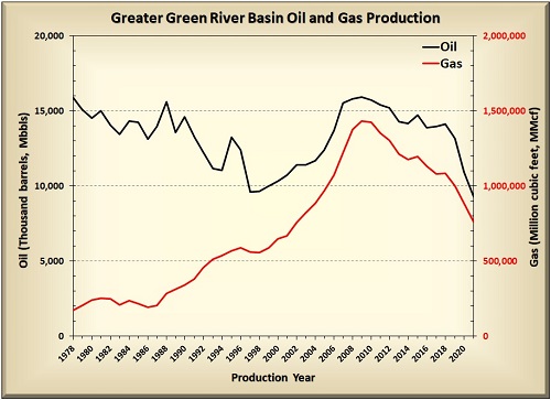
In general, drilling has decreased in the Greater Green River Basin over the past few
years and production has followed this trend. Production continues to decline from
the basin’s 2009 high of 15.9 million barrels of oil and 1.43 trillion cubic feet of
gas (WOGCC, 2023).
However, horizontal drilling and hydraulic fracturing in the Washakie Basin, the far
eastern flank of the basin, and the giant Jonah and Pinedale fields have resulted in
productive natural gas wells. These horizontal wells
are targeting the Fort Union and Lance formations and the Mesaverde Group. Continued
use of these drilling and production technologies may further increase production
from what were historically thought of as tight and
unproductive sandstone or shale reservoirs, but are now rather typical
unconventional reservoirs. Horizontal projects, along with continued infill drilling
and possible development in the Normally Pressured Lance federal
project, may help offset the declining production in the Greater Green River
Basin. However, as always, production remains susceptible to market factors such as
price, supply, and demand.
- ►References
-
Burtner, R.L., and Warner, M.A., 1984, Hydrocarbon generation in Lower
Cretaceous Mowry and
Skull Creek shales of the northern Rocky Mountain areas, in Woodward,
J., Meissner, F.F., and Clayton, J.L., eds., Symposium on hydrocarbon source
rocks of the greater Rocky Mountain Region: Denver, Co., Rocky Mountain
Association of Geologists, p. 449–467.
Carroll, A.R., and Bohacs, K.M., 2001, Lake-type controls on petroleum source
rock potential in nonmarine basins: American Association of Petroleum
Geologists Bulletin, v. 85, no. 6, p. 1,033–1,053.
Cluff, R.M., and Cluff, S.G., 2004, The origin of Jonah field, northern Green
River Basin,
Wyoming, in Robinson, J.W., and Shanley, K.W., eds., Jonah field—Case
study of a giant
tight gas fluvial reservoir: American Association of Petroleum Geologists
Studies in Geology 52 and Rocky Mountain Association of Geologists
Guidebook, chap. 8, p. 127–145.
Grabowski, G.J., Jr., and Bohacs, K.M., 1996, Controls on compositions and
distributions of lacustrine organic-rich rocks of the Green River Formation,
Wyoming [abs.]: San Diego, Calif., American Association of Petroleum
Geologists and Society of Economic Paleontologists and Mineralogists Annual
Meeting, v. 5, p. 55.
Johnson, R.C., 2005, Geologic assessment of undiscovered oil and gas
resources in the Phosphoria
Total Petroleum System, Southwestern Wyoming Province, Wyoming, Colorado,
and Utah, in U.S. Geological Survey Southwestern Wyoming Province
Assessment Team, Petroleum systems and geologic assessment of oil and gas in
the Southwestern Wyoming Province, Wyoming,
Colorado, and Utah: U.S. Geological Survey Digital Data Series DDS-69-D,
chap. 4, 46 p.
Law, B.E., 1988, Geologic framework and hydrocarbon plays in the Southwestern
Wyoming Basins Province: U.S. Geological Survey Open-File Report 88-450-F,
29 p.
Piper, D.Z., and Link, P.K., 2002, An upwelling model for the Phosphoria
sea—A Permian, ocean margin sea in the northwest United States: American
Association of Petroleum Geologists Bulletin, v. 86, no. 7, p. 1,217–1,235.
Roberts, S.B., 2005, Geologic assessment of undiscovered petroleum resources
in the Wasatch—Green River Composite Total Petroleum System, Southwestern
Wyoming Province, Wyoming, Colorado, and Utah, in U.S. Geological
Survey Southwestern Wyoming Province Assessment
Team, petroleum systems and geologic assessment of oil and gas in the
Southwestern Wyoming Province, Wyoming, Colorado, and Utah: U.S. Geological
Survey Digital Data Series DDS-69D, chap. 12, 22 p.
USGS Southwestern Wyoming Province Assessment Team, 2005, Petroleum systems
and geologic assessment of oil and gas in the Southwestern Wyoming Province,
Wyoming, Colorado, and Utah: U.S. Geological Survey Digital Data Series
DDS-69-D.
Warner, M.A., 1982, Source and time of generation of hydrocarbons in the
fossil basin, western
Wyoming thrust belt, in Powers, R.B., ed., Geologic studies of the
Cordilleran thrust belt: Rocky Mountain Association of Geologists, p.
805–815.
Weimer, R.J., 1965, Stratigraphy and petroleum occurrences, Almond and Lewis
formations (Upper Cretaceous), Wamsutter arch, Wyoming: Casper, Wyo.,
Wyoming Geological Association, 19th annual field conference, Guidebook, p.
65–81.
Weimer, R.J., 1966, Time-stratigraphic analysis and petroleum accumulations,
Patrick Draw field, Sweetwater County, Wyoming: American Association of
Petroleum Geologists Bulletin, v. 50, no. 10, p. 2,150–2,175.
WOGCC, 2023, Wyoming Oil and Gas Conservation Commission website, accessed
April 2023, at http://pipeline.wyo.gov/legacywogcce.cfm.
Hanna Basin Geology
Cross Section
Geologic Map
Type
Log
The Hanna Basin is a small yet anomalously deep (9,144 m, 30,000 ft) intermontaine
Laramide-style basin, approximately 64 km (40 mi) east-west and 40 km (25 mi)
north-south.
The basin is bounded to the north by the Shirley and Seminoe mountains, to the east
by Simpson Ridge, to the south by the Medicine Bow Mountains and Park Range, and to
the west by the Rawlins Uplift.
The structural development of the Hanna Basin occurred in multiple stages. The Hanna
Basin was first isolated from the Greater Green River Basin by the uplift of the
Shirley and Granite mountains
during the early Paleocene, followed by middle-Paleocene growth of the Sweetwater
Uplift. The Medicine Bow Mountains and Rawlins Uplift occurred during the late
Paleocene. The Cambrian- through
Jurassic-age sedimentary strata that accumulated before the structural development
of the Hanna Basin are less than 762 m (2,500 ft) thick.
During the Laramide orogeny, the Hanna Basin was isolated from the surrounding basins
and became a closed drainage. This structural configuration resulted in a thick
succession of Upper Cretaceous
to Lower Paleogene fluvial and lacustrine sedimentary deposits. These fluvial and
lacustrine strata account for the bulk of the strata in the basin center, and can be
up to 5,791 m (19,000 ft) thick.
Production
![Haystack Mountains Formation dipping northeast into the Hanna Basin, Haystack Mountains. [Credit: WSGS] Haystack Mountains](../images/energy/hannabasin-haystacks.jpg)
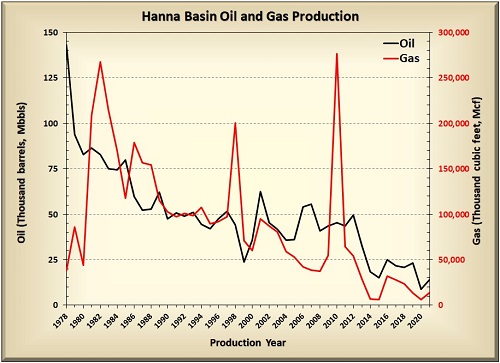
Conventional oil and gas exploration occurred in the Hanna Basin throughout the 20th
century. There are currently 25 named fields in the Hanna Basin, 13 of which are
abandoned or shut-in
(WSGS oil and gas map). The basin’s
most productive oil field, Big
Medicine Bow field, has produced from the Frontier
Formation, Muddy Sandstone, Cloverly (Dakota) Formation, Morrison Formation,
Sundance Formation, and Tensleep Sandstone (WOGCC, 2023).
The most productive gas field, Separation Flats field, produced from the Muddy
Sandstone but is no longer active. The Hanna Basin has not been extensively explored
for undiscovered petroleum
accumulations, and there are potential conventional and unconventional undiscovered
accumulations (Dyman and Condon, 2007).
Coal mining has been active in the Hanna Basin since 1868 (Flores and others, 1999).
Mines operated at the town site of Carbon until 1900, when mining operations moved
to the town of Hanna
after the railroad was rerouted. Most of the coal extraction in the Hanna as well as
Carbon basins (which is separated from the Hanna Basin by the northeast-
southwest-trending Saddleback
Hills anticline) has been from the Hanna coal field (Pierce, 1996).
Coal is primarily mined from the Upper Cretaceous and Paleocene Ferris Formation, as
well as the Paleocene Hanna Formation.
![Tensleep Sandstone, Goose Egg Formation, and Chugwater Formation (foreground), on the flanks of the Seminoe Mountains. [Credit: W.A. Sullivan] Tensleep Sandstone](../images/energy/hannabasin-tensleep.jpg)
Dyman and Condon (2005) define the Hanna-Mesaverde coalbed gas total petroleum system
in the Hanna Basin, as including portions of the Mesaverde (Almond), Medicine Bow,
Ferris, and Hanna formations.
Two coalbed natural gas (CBNG) pilot projects in the basin, established by 2005,
have produced very little gas from this petroleum system. The Seminoe Road CBNG
pilot project contained 16 wells that
produced 1,400 cubic feet of gas per day; the Hanna Draw CBNG pilot project had nine
wells that averaged less than 1,000 cubic feet of gas per day (Dyman and Condon,
2005).
Future Development
Because of the anomalous structure of the Hanna Basin relative to other Laramide
basins (that is, it is a small but very deep basin), exploration targets are limited
to the flanks of the basin—
the basin center is considered too deep for most exploration. There has been very
little exploration in the basin over the past few decades, mostly limited to CBNG
projects. No drilling
projects on federal lands have been proposed in the Hanna Basin.
- ►References
-
Dyman, T.S., and Condon, S.M., 2007, 2005 geologic assessment of undiscovered
oil and gas resources, Hanna, Laramie, and Shirley basins Province, Wyoming
and Colorado, in U.S. Geological Survey Hanna, Laramie, and Shirley
Basins Province Assessment Team, Petroleum systems and geologic assessment
of undiscovered oil and gas, Hanna, Laramie, and Shirley basins Province,
Wyoming and Colorado: U.S. Geological Survey Digital Data Series DDS-69-K,
chap. 2, 62 p.
Flores, R.M., Cavaroc, V.V., Jr., and Bader, L.R., 1999, Ferris and Hanna
coal in the Hanna and Carbon basins, Wyoming—A synthesis: U.S. Geological
Survey Professional Paper 1625-A, chap. HS, 49 p.
Pierce, B.S., 1996, Quality and petrographic characteristics of Paleocene
coals from the Hanna Basin, Wyoming: Jackson, Wyo., 12th Annual Meeting of
the Society of Organic Petrology, Organic Geochemistry, v. 24, no. 2, p.
181–187.
WOGCC, 2023, Wyoming Oil and Gas Conservation Commission website, accessed
April 2023, at http://pipeline.wyo.gov/legacywogcce.cfm.
Laramie Basin Geology
1:100,000-scale bedrock geologic maps
The Laramie Basin, in southeast Wyoming, is a complexly downfolded Laramide basin. It
trends north-south and is approximately 80 km (50 mi) long by 50 km (31 mi) wide.
The Laramie Basin
is bounded by the Medicine Bow Mountains on the west, Hanna Basin on the northwest,
Shirley Mountains on the north, and Laramie Mountains on the east.
The Laramie Basin formed
during the Laramide orogeny, from the Late Cretaceous to middle Paleocene. The
pre-Laramide sedimentary rocks along the flanks of the basement-cored Medicine
Bow Mountains have been extensively folded and faulted. Less deformation is
observed on
the eastern margin where these same sedimentary rocks are tilted and rest
unconformably on the 1,432–1,436 Ma Laramie Anorthosite Complex (Frost and
others, 2013) or the 1,433 Ma Sherman Granite
(Frost and others, 1999) further to the south.
Similar to in other Laramide basins, oil and gas in the Laramie Basin is commonly
found in asymmetric anticlinal traps that occur in the northern half of the
basin. One exception is
a stratigraphic trap in the Muddy Sandstone of the Big Hollow field (Pritchett,
1985). Oil-producing formations in the basin include the Pennsylvanian Tensleep
Sandstone, the Lower
Cretaceous Muddy Sandstone, and the Lakota (Cloverly) Formation. Minor oil
production has also come from the Jurassic Sundance and Upper Cretaceous Wall
Creek formations. The most
productive natural gas reservoirs in the Laramie Basin are the Lakota (Cloverly)
Formation and Muddy Sandstone in the Rock River field, and the Shannon Sandstone
Member of the Upper
Cretaceous Cody Shale in the Dutton Creek field.
![Casper Formation, southwestern Laramie Basin. [Credit: WSGS] Casper Formation](../images/energy/laramiebasin-casper.jpg)
Production
Quealy field in the western Laramie Basin was the first field in the Rocky
Mountain region to be discovered using seismic methods. The California Company
used reflection seismic
surveys to delineate the Quealy Dome anticline and drilled the first productive
well in Quealy field in 1934 (WSGS oil and gas map). Hydrocarbon
exploration and development in the
Laramie Basin has since been limited compared to most of Wyoming’s other
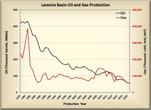
Laramide basins. While oil has been the primary target in the Laramie Basin, six
of the eight currently active fields have also produced gas (WOGCC, 2023).
Future Development
No new wells have been drilled in the Laramie Basin since 2014 (WOGCC, 2023). It
remains to be seen if and when the unconventional plays being targeted
in other Wyoming basins will also be developed in the Laramie Basin.
- ►References
-
Frost, B.R., Bauer, R.L., Scoates, J.S., and Ingram, J.S., 2013, The
Laramie Anorthosite Complex and its contact metamorphic aureole:
Geological Society of America Field Guides, v. 33, p. 237–258.
Frost, C.D., Frost, B.R., Chamberlain, K.R., and Edwards, B.R., 1999,
Petrogenesis of the 1.43 Ga Sherman batholith, SE Wyoming, USA—A
reduced, rapakivi-type anorogenic granite: Journal of Petrology, v. 40,
no. 12, p. 1,771–1,802.
Pritchett, R.W., 1985, Seismic profiles of the western Laramie
Basin—Wyoming, in Gries, R.R., and Dyer, R.C., eds., Seismic
exploration of the Rocky Mountain region: Rocky Mountain Association of
Geologists and Denver Geophysical Society, p. 225–232.
WOGCC, 2023, Wyoming Oil and Gas Conservation Commission website,
accessed April 2023, at http://pipeline.wyo.gov/legacywogcce.cfm.
Overthrust Belt Geology
Cross Sections
The Overthrust Belt is a zone of highly deformed rock layers stretching from northern
Alaska to Mexico. The portion of the Overthrust Belt in Wyoming that has been the
target of oil and gas exploration
efforts is more than 160 km (100 mi) wide and 320 km (200 mi) long. It is bounded to
the north by Jackson Hole, Wyoming, to the east by the Darby and Prospect faults,
and to the south by the Uinta
Uplift.
The Overthrust Belt is not part of the Laramide Basin system, but was instead created
by the Cretaceous-age Sevier orogeny approximately 150 million to 55 million years
ago.
The Sevier orogeny was a shortening event that resulted in "thin-skinned" thrust
faults that do not involve the Precambrian basement rocks.
Often termed the Thrust Belt or Sevier Belt, the Overthrust Belt contains a series of
anticlinal traps that can store hydrocarbons. The complexity of the Overthrust
Belt's geology,
including highly folded and faulted strata, has contributed, and continues to
contribute, to the difficulty of exploring for
oil and gas in this area.
The Jurassic Nugget Sandstone and the Mississippian Madison Limestone have been the
most prolific oil and gas producing formations in Wyoming's Overthrust Belt. Other,
mostly gas-producing,
formations in the Overthrust Belt include the Ordovician Big Horn Dolomite;
Pennsylvanian Amsden Formation; Permian Phosphoria Formation and Weber Sandstone;
Triassic Thaynes Limestone; Jurassic Twin Creek Limestone; Cretaceous Baxter,
Mesaverde, Muddy, and Bear River formations; and Eocene Almy Formation.
![Folded and fractured Madison Limestone. [Credit: R. O'Donnell] Madison Formation](../images/energy/overthrust-madison.jpg)
The main source rock in the Overthrust Belt is presumed to be the Cretaceous Mowry
Shale. The Permian Phosphoria Formation and other Cretaceous organic-rich
formations, such as the Bear River
and Frontier formations, may also be minor sources of oil and gas in the region
(USGS Wyoming Thrust Belt Province Assessment Team, 2003).
Production
![Oil source rock facies (dark gray) of the Phosphoria Formation. [Credit: R. O'Donnell] Phosphoria Formation](../images/energy/overthrust-phosphoria.jpg)
Exploration began in the late 1800s and early 1900s in the Overthrust Belt region,
primarily in shallow fields associated with oil seeps. These small fields were
unsuccessful. Despite
the discovery of the large La Barge and Dry Piney fields in the mid-1900s in the
transition zone between the Greater Green River Basin and the Overthrust Belt,
intensive exploratory efforts
did not commence until the discovery of several fields during the mid-1970s (Ver
Ploeg, 1979).
Twenty-four fields within the Overthrust Belt have been reported as having produced
oil or natural gas (WSGS oil and gas map).
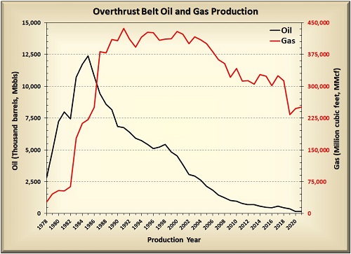
In the 1980s, these fields accounted for more than half of the state’s total gas
production. While this percent has declined, the Overthrust Belt has continued to
contribute between 15 and 19 percent of Wyoming’s natural gas throughout the last
decade. Most of the area’s oil and gas production is from the Whitney Canyon-Carter
Creek, Painter Reservoir, Painter Reservoir East, and Ryckman Creek fields, with the
Whitney Canyon-Carter Creek and Painter Reservoir East fields being the state’s 7th
and 8th most productive gas fields, respectively (WOGCC, 2023).
Future Development
No productive wells have been drilled
in the area since 2012, and at this point, there appears to be no new Overthrust
Belt oil or gas projects on the horizon.
- ►References
-
USGS Wyoming Thrust Belt Province Assessment Team, 2003, Assessment of
undiscovered oil and gas resources of the Wyoming Thrust Belt Province: U.S.
Geological Survey World Energy Assessment Project Fact Sheet.
Ver Ploeg, A.J., 1979, The Overthrust Belt—An overview of
an important new oil and gas province: Geological Survey of Wyoming
[Wyoming State Geological Survey] Public Information Circular 11, 15 p.
WOGCC, 2023, Wyoming Oil and Gas Conservation Commission website, accessed
April 2023, at http://pipeline.wyo.gov/legacywogcce.cfm.
Powder River Basin Geology
Cross
Section
Geologic Map
Type Log
Upper Cretaceous Strata
The Powder River Basin area encompasses the Powder River structural basin and Powder
River energy basin. The structural basin is an asymmetric trough in southeastern
Montana and northeastern Wyoming
that trends north-south for approximately 401 km (250 mi) and is 161 km (100 mi)
wide. It is bounded to the south by the Casper Arch, Laramie Mountains, and
Hartville Uplift; to the west by the
Bighorn Mountains; to the north by the Miles City arch in Montana; and to the east
by the Black Hills. The Powder River energy basin is loosely defined by the
Cretaceous–Tertiary boundary observed in
outcrops.
Formations in the Powder River Basin have near-vertical to overturned dips along the
western margin and gentle sub-horizontal (basinward) dips along the eastern margin.
Laramide structural deformation began in the Powder River Basin region during
deposition of the Upper Cretaceous (Maastrichtian) Lewis Shale and ended during
deposition of the Eocene Wasatch Formation (Curry, 1971).
Together, Sevier subsidence and Laramide deformation resulted in structural relief
greater than 7,620 m (25,000 ft; Blackstone, 1981). Nearly 2,438 m (8,000 ft) of
syn-Laramide sedimentary rocks are preserved
within the Powder River Basin (Curry, 1971).
Conventional hydrocarbon fields within the Powder River Basin generally occur as
stratigraphic traps or in basin-bounding anticlinal structures in Paleozoic and
lower Mesozoic strata. The Tensleep Sandstone and Minnelusa Formation are the major
Paleozoic oil producers. According to Dolton and others (1990), the Tensleep
primarily produces from structural (anticlinal) traps and the Minnelusa produces
from both structural and stratigraphic traps.
![Clear Creek thrust on western border of the Powder River Basin near Buffalo, WY. [Credit: WSGS] Clear Creek thrust](../images/energy/prb-clearcreek.jpg)
The hydrocarbon source rocks that likely charged the Tensleep and Minnelusa
reservoirs were Permian shales in western Wyoming. Dolton and others (1990) argue
that the hydrocarbons were generated by Jurassic time,
migrated east, and were trapped until the Laramide orogeny.
Subsequent uplift allowed some hydrocarbons to escape, while some remained in the
Tensleep and Minnelusa reservoirs. In the eastern parts of the basin, lower
Minnelusa reservoirs may have been locally sourced from
interbedded black shales (Clayton and Ryder, 1984).
Formations deposited during the Cretaceous represent the other major hydrocarbon
reservoirs in the Powder River Basin. Although operators did produce from
conventional wells in Cretaceous reservoirs such as the
Muddy Sandstone (western equivalent of the Newcastle Sandstone), Frontier Formation,
and the Carlile Shale, historically less-productive Cretaceous-age unconventional
reservoirs are now the main focus of
exploration and production in the Powder River Basin. These unconventional
reservoirs include the Lakota Formation, Fall River (Dakota) Sandstone, Mowry Shale,
Wall Creek Sandstone Member of the Frontier
Formation, the Turner Sandstone Member of the Carlile Shale, Niobrara Formation,
Shannon and Sussex sandstone members of the Cody Shale, Teapot and Parkman sandstone
members of the Mesaverde
Formation, and the Teckla Sandstone Member of the Lewis Shale.
The source rock for most of the Upper Cretaceous hydrocarbon reservoirs is the Mowry
Shale, with significant contributions from the Niobrara Formation and Carlile Shale
(Momper and Williams,
1984; Dolton and others, 1990). Hydrocarbons were generated in the deeper western
part of the basin and migrated up-dip toward the east into the Cretaceous
reservoirs. Estimates suggest nearly 12
billion barrels of oil were generated in the Mowry Shale (Momper and Williams,
1984).
Production
![Wall Creek Member of the Frontier Formation, near Kaycee, WY. [Credit: Rebekah Rhodes] Frontier Formation](../images/energy/prb-wallcreek.jpg)
Development of the Powder River Basin (WSGS oil and gas map) as a
hydrocarbon-producing basin occurred more slowly than in the other Laramide basins.
The first producing oil well in the basin was drilled in 1889 north of Salt Creek field, which is still the
most productive oil field in Wyoming.
More than 725 named fields and numerous wildcat wells have since been developed in
the basin.
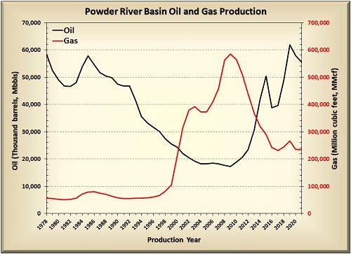
Oil production in the Powder River Basin has fluctuated through several boom and bust cycles.
In 2010, oil production from unconventional reservoirs in the basin started
increasing dramatically, and in 2019 reached levels not seen since the late 1980s
(WOGCC, 2023). Beginning in 2014, more than half of all oil produced in Wyoming each
year has come from the Powder River Basin, with a contribution nearing 69 percent in
2022 (WOGCC, 2023).
Gas occurrences in the Powder River Basin were historically rare and were usually gas
caps associated with oil reservoirs. However, coalbed natural gas (CBNG) development
in the late 1990s and 2000s
changed the Powder River Basin into a significant natural gas-producing region. At
its peak in 2009, the Powder River Basin produced more than 584 billion cubic feet
of natural gas (WOGCC, 2022). Except for a slight uptick in 2018 and 2019 associated
with prolific oil wells, natural gas production has been declining or flattening in
the Powder River Basin since 2009. This trend is largely due to low gas prices,
depleted CBNG reservoirs, and competition from large unconventional gas plays.
Future Development
Thick sequences of stacked, unconventional reservoirs will continue to be the focus
of development within the Powder River Basin. The Frontier, Niobrara, Parkman,
Turner, and Shannon sandstones were the basin’s five most productive reservoirs in
2022 (WOGCC, 2023). Large-scale oil and gas developments such as the Converse County oil and gas project
are currently targeting these and other Upper Cretaceous units (WSGS oil and gas map).
Technology will also play a vital role in developing the basin’s
previously-uneconomic tight sands and shales. Horizontal well laterals are now being
drilled up to 9,000 feet in length in the
Powder River Basin, increasing the intersected reservoir surface area and
potentially boosting yields. Advances in hydraulic fracturing, such as intense
multi-stage “cloud fracking”, will continue
to improve primary recovery. In addition, the University of Wyoming, along with
industry partners, is establishing a laboratory
to identify the well fracturing, design, and completion technologies that will
enhance production from the Powder River Basin’s more-challenging Mowry and Belle
Fourche shale reservoirs.
- ►References
-
Blackstone, D.L., Jr., 1981, Compression as an agent in deformation of the
east-central flank of the Bighorn Mountains, Sheridan and Johnson counties,
Wyoming: Contributions to Geology, v.19, no. 2, p. 105–122.
Clayton, J.L., and Ryder, R.T., 1984, Organic geochemistry of black shales
and oils in the Minnelusa Formation (Permian and Pennsylvanian), Powder
River Basin, Wyoming, in Woodward, J., Meissner, F.F., and Clayton,
JL., eds., Hydrocarbon source rocks of the greater Rocky Mountain region:
Denver, Colo., Rocky Mountain Association of Geologists, p. 231–244.
Curry, W.H., Ill, 1971, Laramide structural history of the Powder River
Basin, Wyoming: Casper, Wy., Wyoming Geological Association, 23rd annual
field conference, Guidebook, p. 49–60.
Dolton, G.L., Fox, J.E., and Clayton, J.L., 1990, Petroleum geology of the
Powder River Basin, Wyoming and Montana: U.S. Geological Survey Open-File
Report 88-450-1), 64 p.
Hughes, L., 1983, Case histories of an electromagnetic method for petroleum
exploration: Prepared by Zonge Engineering and Research Organization, Inc.,
Tucson, Ariz., 332 p.
Momper, J.A., and Williams, J.A., 1984, Geochemical exploration in the Powder
River Basin, in Demaison, G., and Murris, R.J., eds., Petroleum
geochemistry and basin evaluation: Tulsa, Okla., American Association of
Petroleum Geologists Memoir 35, p. 181–191.
WOGCC, 2023, Wyoming Oil and Gas Conservation Commission website, accessed
April 2023, at http://pipeline.wyo.gov/legacywogcce.cfm.
Wind River Basin Geology
Cross
Sections
Geologic Map
Type Log
The Wind River Basin, in central Wyoming, is an east-west elongate structural basin
of typical Laramide style, 115 km (71 mi) wide by 300 km (186 mi) long. The primary
basin axis trends
northwest-southeast, and is asymmetrically located near the northern basin margin.
The basin is bounded by the Wind River Range on the west, the Owl Creek Mountains on
the north, the Casper
Arch to the east, and the Granite Mountains to the south.
Significant deformation occurred in the Wind River Basin during the Laramide orogeny
that resulted in a basin center greater than 7,620 m (25,000 ft) deep, beds dipping
10–20 degrees
toward the basin center on the south and western margins, and near-vertical to
overturned strata on the north and eastern margins (Keefer, 1969). A thick
succession of undeformed
post-Laramide basin-fill strata was deposited unconformably on the pre-Laramide
(pre-Eocene) rocks.
In the Wind River Basin, hydrocarbon traps typically consist of structural features
such as domes, anticlines, or faulted anticlines (Keefer, 1969) situated on the
basin margins in rocks
deposited previous to or coincident with Laramide-age faulting. Other types of
structural traps include anticlines or domes near the basin axis, traps beneath the
basin-bounding
thrust faults, or sub-thrust plays (Fox and Dolton, 1996).
Some purely stratigraphic traps are also found in the Wind River Basin. The most
frequent stratigraphic traps are lateral up-dip (to the east) facies changes in the
Phosphoria, Park City, and
Goose Egg formations. Others include sandstone pinch-outs in the reservoirs of the
Frontier Formation, Mesaverde Group, and Muddy Sandstone, as well as vertical and
lateral cementation
variations in Tensleep Sandstone reservoirs. In some cases, structural traps are
enhanced by the effects of stratigraphic-trapping. For example, oil and natural gas
in Morrison Formation sands
are held by a combination structural-stratigraphic trap on the nose of a domal
structure in the Poison Spider West field (Gouger, 1989).
![Photo mosaic of the Tensleep Sandstone in Wind River Canyon. [Credit: WSGS] Tensleep Sandstone](../images/energy/windriver-tensleep.jpg)
The Tensleep Sandstone and Phosphoria and Park City formations comprise the primary
reservoir rocks in the basin. The bulk of the hydrocarbons in these formations were
sourced from the black shales
of the Mead Peak and Retort members of the Phosphoria Formation in western Wyoming
and eastern Idaho (Sheldon, 1967; Stone, 1967; Kirschbaum and others, 2007).
Migration began soon after generation,
and may have been associated with Sevier orogenesis. Hydrocarbons moved up-dip,
likely via the porous and permeable Tensleep Sandstone, into the area that is now
the Wind River Basin and were trapped
by the overlying impermeable Goose Egg Formation (Stone, 1967; Kirschbaum and
others, 2007). Laramide faulting and folding was responsible for the subsequent
rearrangement of the hydrocarbons into
their present day structural and stratigraphic traps. Phosphoria-sourced
hydrocarbons are commonly high in sulfur, exhibit high American Petroleum Institute
(API) gravities, and are classified as
Type-IIS (Kirschbaum and others, 2007).
Production
Oil production in the Wind River Basin and Wyoming began with the completion of the
Mike Murphy #1 well in 1884, just five years after America's first commercial oil
well was drilled. The Mike Murphy #1 well was completed in the Chugwater Group to a
depth of 91 m (300 feet; Mullen, 1989; De Bruin, 2012), and was the discovery well
for the Dallas (or Dallas Dome) field in the
southwestern Wind River Basin. The basin also contains the first logged well in
Wyoming (Atlantic Richfield Company Muskrat 2C, September 1936) and the deepest
completed well in the Rocky Mountain region (Burlington Resources Big Horn 1-5, Madden field), which was completed
between 23,758 and 23,902 ft in the Madison Limestone.
![Triassic Chugwater Group near Burris, WY. [Credit: WSGS] Chugwater Group](../images/energy/windriver-chugwater.jpg)
Of the 118 named fields in the Wind River Basin, 63 primarily produce oil and 55
primarily produce natural gas from reservoirs ranging in age from Mississippian to
Eocene (WSGS oil and gas map).
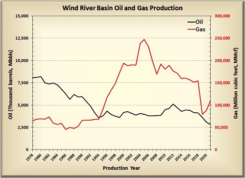
Oil production in the Wind River Basin declined from 1978 through 1994, but has
since remained relatively steady at 3–5 million barrels per year (WOGCC, 2023). This
consistent production is due to the use of efficient secondary and tertiary
production techniques such as the CO2-EOR project at Beaver Creek field.
Future Development
Although it is possible that small undiscovered petroleum accumulations exist in the
Wind River Basin (Fox and Dolton, 1996), it is more likely that any significant
future increases in oil production will be the result of improved recovery methods.
After fifteen years of declining gas production, natural gas production in the Wind
River Basin began to increase in 2020. This upward trend is expected to continue as
Aethon Energy and Burlington Resources develop the 4,250 wells in northeastern
Fremont County and northwestern Natrona County approved as part of their Moneta Divide project.
- ►References
-
De Bruin, R.H., 2012, Oil and gas map of Wyoming:
Wyoming State Geological Survey Map Series MS-55, scale 1:500,000.
Fox, J.E., and Dolton, G.L., 1996, Wind River Basin Province (035), in
Gautier, D.L., Dolton, G.L., Takashashi, K.I., and Varnes, K.L., eds., 1995
National assessment of United States oil and gas resources—Results,
methodology, and supporting data: U.S. Geological Survey Digital Data Series
DDS-30, release 2, 21 p.
Gouger, B.l., 1989, Poison spider west, in Cardinal, D.F., Miller, T.,
Stewart, W.W., and Trotter, J.F., eds., Wyoming oil and gas fields symposium
Bighorn and Wind River basins: Casper, Wyo., Wyoming Geological Association,
p. 380–383.
Johnson, R.C., Finn, T.M., Kirschbaum, M.A., Roberts, S.B., Roberts, L.N.R.,
Cook, T., and Taylor, D.J., 2007, The Cretaceous-Lower Tertiary Composite
Total Petroleum System, Wind River Basin, Wyoming, in U.S. Geological
Survey Wind River Basin Province Assessment Team, Petroleum systems and
geologic assessment of oil and gas in the Wind River Basin Province,
Wyoming: U.S. Geological Survey Digital Data Series DDS-69-J, chap. 4, 96 p.
Keefer, W.R., 1969, Geology of petroleum in Wind River Basin, central
Wyoming: American Association of Petroleum Geologists Bulletin, v. 53, no.
9, p. 1,839–1,865.
Kirschbaum, M.A., Lillis, P.G., and Roberts, L.N.R., 2007, Geologic
assessment of undiscovered oil and gas resources in the Phosphoria Total
Petroleum System of the Wind River Basin Province, in U.S. Geological
Survey Wind River Basin Province Assessment Team, Petroleum systems and
geologic assessment of oil and gas in the Wind River Basin Province,
Wyoming: U.S. Geological Survey Digital Data Series DDS-69-J, chap. 3, 27 p.
Mullen, C., 1989, Dallas, in Cardinal, D.F., Miller, T., Stewart,
W.W., and Trotter, J.F., eds., Wyoming oil and gas fields symposium Bighorn
and Wind River basins: Casper, Wyo., Wyoming Geological Association, p.
114–116.
Sheldon, R.P., 1967, Long-distance migration of oil in Wyoming: Mountain
Geologist, v. 4, no. 2, p.53–65.
Stone, D.S., 1967, Theory of Paleozoic oil and gas accumulation in Bighorn
Basin, Wyoming: American Association of Petroleum Geologists Bulletin, v.
51, no. 10, p. 2,056–2,114.
WOGCC, 2023, Wyoming Oil and Gas Conservation Commission website, accessed
April 2023, at http://pipeline.wyo.gov/legacywogcce.cfm.